The World Below the Thermocline
At eight hundred meters beneath the hull of our vessel in the North Atlantic, the last stray photon of solar light is absorbed by water molecules. Around the same depth, the temperature drops precipitously across the permanent thermocline, settling into a uniform, unvarying two degrees Celsius that extends all the way down to the benthic mud at four thousand five hundred meters.
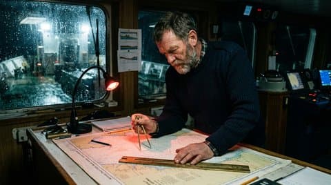
Up on the bridge, under the dim crimson glow of the night-vision chart lamp, we watch the multibeam bathymetric sonar paint the floor of the abyss in false-color contours across the bulkhead monitor. Down there, in a pressure regime exceeding four hundred atmospheres, there are no seasons, no weather fronts, no day or night, and no national flags. There is only the slow rain of marine snow—calcified foraminifera shells and organic detritus drifting down from the photic zone—and the vast, silent topography of the abyssal plains, interrupted by volcanic seamounts, fracture valleys, and submarine canyons deeper than the Grand Canyon.
Yet across this primordial floor run the slender glass arteries of twenty-first-century civilization. Every diplomatic cable, every sovereign bond auction, every interbank SWIFT settlement, and every artificial intelligence training synchronization passes through this cold darkness—utterly dependent on the geological mercy of a world we barely understand and have mapped at lower resolution than the surface of Mars or Venus.
Submarine Avalanches and the Lesson of the Grand Banks
Land-dwelling engineers tend to imagine the deep ocean floor as a tranquil sediment basin where nothing moves for millions of years. Any mariner who has studied the history of submarine telegraphy and fiber optics knows better.
On November 18, 1929, a magnitude 7.2 earthquake struck the continental slope south of Newfoundland along the Laurentian Channel. The tremor itself did not snap the twelve transatlantic telegraph cables lying along the seabed; instead, it dislodged hundreds of cubic kilometers of water-saturated continental shelf mud.
That mud accelerated down the continental slope, transforming into a catastrophic submarine avalanche—what geologists call a benthic turbidity current. Moving at speeds exceeding one hundred kilometers per hour and carrying boulders and gravel in a dense, turbulent slurry, the current tore across nearly a thousand kilometers of the abyssal plain, snapping one transatlantic cable after another in a precise, clockwork sequence over thirteen hours.
Benthic Geological Zone | Depth Envelope | Dominant Physical Hazard | Cable Engineering Countermeasure |
|---|---|---|---|
Littoral & Continental Shelf | 0 to 200 meters | Ship anchors, otter-board bottom trawls, and coastal wave scour | Articulated cast-iron split pipes; 3-meter hydraulic plow burial |
Continental Slope & Canyons | 200 to 3,000 meters | High-velocity benthic turbidity currents and slope slumping | Route detouring around canyon axes; double-armored rock-wrap (Type RA) |
Mid-Ocean Tectonic Ridges | 2,000 to 3,500 meters | Hydrothermal vents, basaltic talus scarps, and seismic faulting | Precision ROV visual micro-routing; low-tension catenary slack control |
Abyssal Plains | 3,500 to 6,000 meters | Abyssal hills, manganese nodule abrasion, and hydrostatic creep | High-density polyethylene (HDPE) sheath over hermetically welded copper |
Subduction Trenches | 6,000 to 11,000 meters | Extreme hydrostatic crushing (> 600 bar) and megathrust slip | Titanium repeater vessels; ultra-high-tensile steel wire strand cores |
In the modern fiber-optic era, the danger has only intensified. In December 2006, the Hengchun earthquake off southern Taiwan triggered submarine landslides down the Kaohsiung Canyon that severed nine separate undersea cable systems simultaneously at depths of four thousand meters, paralyzing financial markets and internet traffic across East and Southeast Asia for weeks while eleven cable ships fought winter monsoons to recover the buried ends.
Core Samples From Four Kilometers Down
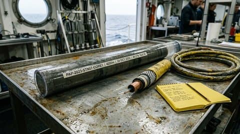 Polycarbonate abyssal sediment core tube beside armored subsea cable section
Before a new transoceanic cable route is ever laid, our survey ships steam along the proposed corridor taking gravity piston cores of the seabed and towing deep-water side-scan sonar fish fifty meters above the bottom.
Look at the polycarbonate core tube resting on our wet laboratory bench above, pulled from four thousand two hundred meters in the Porcupine Abyssal Plain at 49°12'N, 14°38'W. Beneath the top ten centimeters of soft, tan pelagic ooze—composed of the microscopic skeletons of plankton laid down at a rate of two centimeters per thousand years—lies a sharp, dark boundary of coarse basaltic sand and graded silt.
That dark band is the signature of a prehistoric turbidity flow that swept down from the Celtic shelf three thousand years ago.
The Benthic Route Engineering Sequence: Multibeam Swath Bathymetry Survey → Sub-Bottom Acoustic Profiling → Piston Core Stratigraphic Sampling → Canyon & Seamount Hazard Avoidance Routing → Slack-Programmed Abyssal Laying
When I lay my brass dividers across the Admiralty chart on the bridge, I am reading a geological palimpsest. We do not lay cable in a straight great-circle line between Cornwall and Halifax. We thread a needle between ancient submarine landslides, volcanic calderas, cold-water Lophelia coral mounds, and unexploded munitions dumps left over from the Battle of the Atlantic. If the survey chief misreads a sub-bottom acoustic profile and routes the cable across a suspended rock pinnacle on the Mid-Atlantic Ridge, bottom currents vibrating the suspended span—a phenomenon called vortex-induced vibration—will saw through the polyethylene jacket against the jagged basalt in less than eighteen months.
The Geopolitics of the Maritime Chokepoint
For five centuries, naval strategists from Alfred Thayer Mahan to Julian Corbett understood that global trade was governed by a handful of narrow maritime chokepoints: the Strait of Malacca, the Bab-el-Mandeb, the Suez Canal, the Strait of Gibraltar, the Danish Straits.
Today, the geography of global computation is captive to those exact same narrow waters.
Because undersea cables cannot cross sovereign landmass without complex territorial treaties and terrestrial sabotage risks, intercontinental fiber networks are funneled through the same shallow maritime bottlenecks as oil supertankers and container ships. Through the Red Sea and the Bab-el-Mandeb—a channel barely twenty miles wide and two hundred meters deep—pass seventeen major subsea cable systems carrying more than ninety percent of all data traffic between Europe and Asia.
When anchors dragged by damaged merchant vessels in the Red Sea severed three of those cables in early 2024, a quarter of the traffic between Frankfurt and Singapore had to be rerouted around the Cape of Good Hope in milliseconds. The physical reality of nineteenth-century maritime geography reasserted itself instantly over the twenty-first-century illusion of borderless cloud computing.
From the Great Eastern to the Modern Cable Layer
Every chief officer who steps onto the bridge of a modern dynamic-positioning cable ship inherits a lineage forged in the summer of 1866 aboard Isambard Kingdom Brunel’s iron leviathan, the SS Great Eastern. When Captain James Anderson and the physicist William Thomson—later Lord Kelvin—succeeded in grappling the lost 1865 telegraph cable from two miles down in the North Atlantic after thirty-attempts with iron hooks and hemp-and-wire rope, they proved that the abyss was not beyond human reach, provided one respected its mechanical laws.
What has changed between Kelvin’s mirror galvanometer in Heart's Content, Newfoundland, and our coherent optical transponders in Bude is merely the carrier frequency of the electromagnetic wave. The ocean itself has not yielded a single inch of its ferocity.
Indeed, when our ROV cameras inspect cables laid forty years ago—such as the early TAT-8 transoceanic optical system put down in 1988—we see how quickly the benthic biosphere incorporates human artifacts into geological time. Crinoids, glass sponges, and deep-water anemones anchor themselves to the galvanized armor wires where the cable crosses rocky sills. In the soft Globigerina ooze of the abyssal plain, burrowing polychaete worms and holothurians slowly bury the black polyethylene jacket beneath millimeter-thin layers of biogenic sediment. The sea treats our proudest technological monuments with the same quiet patience with which it digested Roman amphorae, Spanish galleons, and twentieth-century dreadnoughts.
The Humility of the Deep Watch
At four bells in the middle watch—two o’clock in the morning—the bridge of a cable ship is one of the quietest places on earth.
The helmsman stands silent by the dynamic-positioning joystick; the radar sweep turns steadily in green phosphorus rings; and outside the heated glass of the forward windows, the black swells of the North Atlantic rise and fall under a sky cleared by a cold northwest wind. Four kilometers straight down beneath our keel, our remotely operated vehicle is crawling along the seabed on rubber tracks, its titanium manipulator arms guiding a seventeen-millimeter fiber cable into a trench cut in clay that has not felt sunlight since the Jurassic period.
Up on land, millions of people are asleep with smartphones on their nightstands, dreaming inside a civilization that believes it has conquered space, time, and material limits.
Down here on the water, we know that their entire luminous world hangs by a thread of glass no thicker than an eyelash, resting in the freezing mud of the abyssal plain, tolerated only by the vast, ancient silence of the sea.